
Soon after moving to Cape Ann in 2003, I began mapping cellar holes, trails, stone walls, and other features I encountered in Dogtown. In 2007 I published a map and guidebook based on the GPS data collected and cross-referenced to historical sources. In 2015 the Friends of Dogtown received a grant from the Awesome Gloucester Foundation to create a digital map of Dogtown that could be used by all.
With the closure of the website next year that hosts the Google Maps application I have created a new Discover Dogtown map that contains all of the trails and points of interest discussed in The Dogtown Guide, The Island Woods, and The Cellars Speak with the exception of the old granite quarries of Cape Ann that are on private or restricted land.
Click here to use this map in Google Maps.
The original Google Maps app framework provided certain capabilities I used to create links (similar to the City of Gloucester’s QR codes) at numerous locations in Dogtown to historical information and photographs. Although the above map does not contain the same links, the following tables list all of the places of interest, Babson Boulders, cellar holes, other structures, and memorial markers that are shown in the map. Additional information is provided below and in my books, The Dogtown Guide, The Island Woods, and The Cellars Speak.
Places of Interest
| N1/L1 | Whale’s Jaw |
| N2/L2 | Peter’s Pulpit |
| N3/L3 | Scenic view (seasonal) |
| N4/L4 | Briar Swamp “boardwalk” |
| L5 | Grout ridge |
| L6 | Stone footbridge |
| L7 | Stone footbridge |
| N5 | Old quarry |
| N6 | The Commons |
| N7 | Granny Day’s Swamp |
| N8 | Adam’s Pines |
| N9 | Terminal moraine |
| N10 | Norton Memorial Forest |
| N10 | James Merry Pasture |
| N11 | Location of Marsden Hartley’s 1931 painting “Summer Outward Bound, Gloucester” |
| N12 | Goose Cove Reservoir |
| N13 | Babson Reservoir |
Babson Boulders
| B1 | Get A Job |
| B2 | Help Mother |
| B3 | Be True |
| B4 | Be Clean |
| B5 | Save |
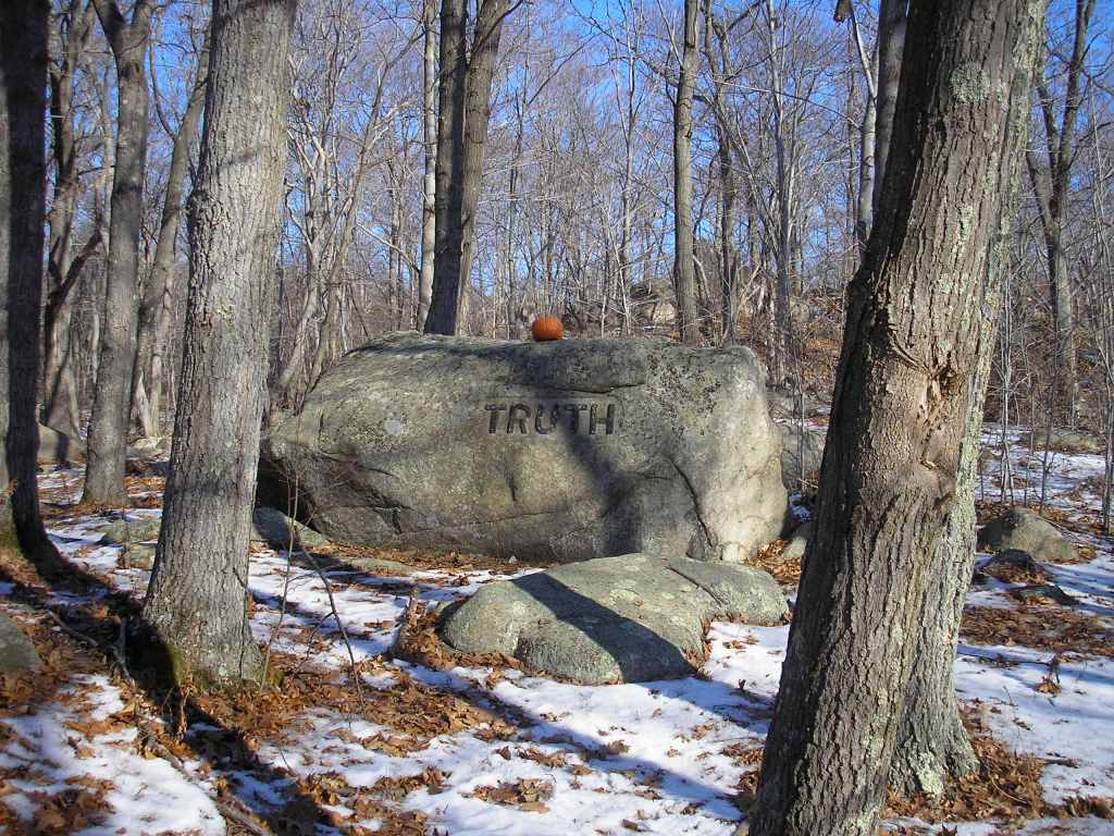
| B6 | Truth |
| B7 | Work |
| B8 | Courage |
| B9 | To Rockport |
| B10 | Loyalty |
| B11 | Kindness |
| B12 | Intelligence |
| B13 | Ideals |
| B14 | Ideas |
| B15 | Integrity |
| B16 | Initiative |
| B17 | Industry |
| B18 | Spiritual Power |
| B19 | Be On Time/Study |
| B20 | Prosperity Follows Service |
| B21 | If Work Stops Values Decay |
| B22 | Keep Out Of Debt |
| B23 | Moraine |
| B24 | D. T. Sq. (2 Boulders) |
| B25 | Never Try Never Win |
| B26 | Use Your Head |

Cellar Holes
| 7 | Benjamin Stanwood |
| 9 | Joseph and Hannah Davis Clark Sr., John and Ruth Haskell Clark |
| 14 | John Day, (Deacon) Joseph and Sarah Day Winslow, Hannah Stevens |
| 15A | James Demerit, Anne Carter |
| 16 | Joseph Ingersoll family |
| 20 | Anthony Day, Joseph and Elizabeth Gauge Day, Jane Boyd Day |
| 21 | James Witham, Stephen Robinson Jr. |
| 22 | Andrew Riggs, Joseph and Priscilla Riggs |
| 27 | Anthony Bennett “The Castle” |
| 32 | John and Ann Harraden Davis |
| 33 | Arthur and Martha Lee Wharf |
| X | Jabez Hunter |
| W | Joshua and Alice Low Elwell |
| 36 | Benjamin and Deborah Norwood Harraden, James Marsh, James Wharf |
| S | Jonathan Stanwood family, Mollie Jacobs, Sarah Phipps |
| 39,40 | Benjamin and Mary Riggs Allen, Abraham and Mary Allen Wharf |
| 11 | Unknown |
| 10 | Henry Davis |
| 12 | William Wilson, Phillip and Naomi Clark Priestley |
| 13 | Joseph and Mary Winslow Stevens |
| 17 | Dorcas Foster (Hadley) |
| 18 | Isaac and Fanny Brundle Dade |
| 19 | Mollie Jacobs, Sarah Phipps, Abigail Stanley |
| 23 | Col. William Pearce |
| 24 | Abraham and Mary Allen Wharf |
| 25 | Peter and Sarah Wharf Lurvey |
| 28 | Bennett Farm |
| 29 | Cobbler Shop |
| 30 | John Morgan Stanwood |
| 34 | Whipple |
| 35 | James Wharf |
| 37 | Wither |
| 38 | White |
| 15 | James Stanwood, Joseph Clark Jr., Isaac Davis, Easter Carter, “Old Ruth”, Becky Rich |
| 31 | Thomas Riggs Jr., Thomas and Lydia Riggs Canneby, Andrew Grimes, “Jim” White |
| R,T | William Hilton and Mary Tucker, Liz Tucker, Judy Rhines, Neil Finson |
| 20A | Joseph and Jane Boyd Day |

Other Structures
| S1 | First Mill |
| S2 | Babson Museum |
| S3 | Schoolhouse |
| S4 | Cut stone foundation |
| S5 | Cut stone wall |
| S6 | Fieldstone foundation and fireplace |
| S7 | Fieldstone foundation stones |
| S8 | Fieldstone and cement foundation |
| S9 | Blatchford cellar |
| S10 | Stone shed |
| S11 | Stone building |
| S12 | Norwood mill |
| S13 | Baker’s mill |
Memorial Markers
| M1 | James Merry |
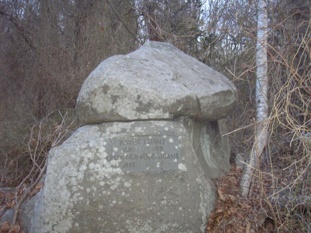
| M2 | Rayne Adams |
| M3 | John Rowe |
| M4 | Anne Natti |
Additional Information for Selected Features
Adams Pines (N8)
Like the Norton Forest to the north, Adams Pines was planted with pine trees. A memorial marker can be found nearby along with the granite foundation of a house that was abandoned around 1930.
Allen Cellar (39)
Cellar 39 is in the middle of Dogtown at the eastern end of Common Road. The house was occupied by Benjamin Allen and his wife Mary Riggs Allen in 1741. Their daughter, Mary, married Abraham Wharf in 1762 and lived at Cellar 24 on Wharf Road. After Benjamin Allen died, the Wharfs moved back here. Other members of the Allen family may have lived in this house as well.
Babson Reservoir (N13)
The Babson Reservoir was built in 1930 in response to a city-wide water shortage that year. The land, which was owned by Roger Babson and his family, was given to the City of Gloucester provided the land surrounding the reservoir be “for the use and enjoyment of the public forever, but on foot only.”

Rocky landscapes such as John Sloan’s “Dogtown, Ruined Blue Fences,” (1916) shown above depict Dogtown during Babson’s time. The view looks west into the valley that would later become the Babson Reservoir. (Image courtesy Cape Ann Museum)
Briar Swamp (N4)
Experts estimate that there are about 5,000 varieties of plants on Cape Ann. Many can be found in the Briar Swamp including the insectivorous Pitcher plant.
Cellar (S)
This cellar is several hundred yards north of Common Road. The easiest way to get to it is by following a stone wall into the woods east from the Goose Cove Reservoir service road. According to the Batchelder map, Nehemiah Stanwood lived here in 1741. Their son, John Morgan Stanwood, married Peter Lurvey’s daughter, Mary. At some point, the Stanwoods left the house and Mollie Jacobs and Sarah Phipps moved in along with Mrs. Stanley, who had also been living with them on Dogtown Road at Cellar 19. Mrs. Stanley’s grandson, Sam Maskey, took care of them. According to Mann, shortly before the last of the ladies left, Neil Finson moved into the cellar for a while before moving into Liz Tucker’s house (Cellar R,T). The Stanwood house was bought by a man named Whipple who later sold it to Isaac and Reuben Day, who dismantled and moved it to Washington Street in Riverdale.
Clark Cellar (9)
In the June 1874 issue of Atlantic Monthly, Gloucester poet Hiram Rich published a piece entitled “Morgan Stanwood” that commemorated the heroism of Peter Lurvey killed in battle fighting the British in Gloucester during the Revolutionary War. Years later when writing The Story of Dogtown, Charles Mann realizes that the line from Rich’s poem “Here the doorstep lies” was a reference to the Clark cellar (9) located here. The doorstep is the only part of the house that still exists.
The Commons (N6)
The Commons was once a hardwood forest that was harvested by the early settlers. Land grants in 1688 gave each resident of Gloucester their own six-acre lot, plus use of these woodlands. Eventually, the area became pastureland grazed by sheep and other animals as shown in this photo from the early 20th Century.
(Image courtesy Sandy Bay Historical Society)
After Dogtown was abandoned in the early 1800s the land began to revert back to the secondary forest we see today.
Day Cellars (20, 20A)
The ownership of two cellars on either side of Granny Day’s Swamp is confusing. Cellar 20 is on a knoll west of the swamp. Records indicate that Anthony Day gave this land, which included a house and barn, to his youngest son, Joseph, in 1704. At some point before Batchelder’s 1741 survey, Joseph Day and his wife, Elizabeth, moved to Attleboro, Massachusetts, where she died in 1724. His son Joseph Day Jr. married Jane Boyd in 1719. Batchelder shows a widow Jane Day living at Cellar 20 in 1741. There is no record of where or when Jane passed away, but Joseph Jr. died in York, Maine, in 1785. If he moved away before 1741, Jane Day would have been the only adult living in this house at the time of the Batchelder survey, thus explaining why her name is associated with this cellar.
A cellar, which we designate 20A, was excavated by Irving Sucholeiki in the 1990s. Isaac Day’s and X. D. Tingley’s maps both show Jane Day’s home and schoolhouse next to each other east of the swamp along Wharf Road. Mann tells us her cellar would often flood. According to the Commoner’s Record, her father-in-law, Joseph Day Sr. originally bought this land in 1708, perhaps to build a house for his son and wife. It is not known why Jane Day moved from the house west of the swamp to this particular place, which often floods in the spring. Nevertheless, she must have been here for a while to have earned the nickname “Granny” Day.
Easter Carter Cellar (15)
The stone marker “15” is on the left across the road from a house that was once up this hill on the south side of Dogtown Road. According to Charles Mann in The Story of Dogtown, the house did not have a cellar and was the only two-story house in Dogtown. The house and the back of the hill on which it stood are gone, replaced by a depleted gravel pit. On Batchelder’s 1741 map, this site is very close to the location of a house occupied by James Stanwood. Either James Stanwood born in Gloucester in 1690, or his father John, who received one of the 1688 land grants, probably built the house. According to Tristram Griffin, other occupants included Joseph Clark Jr., another son of Joseph Clark Sr., who lived at Cellar 9, and Isaac Davis, who married Stanwood’s daughter. Easter Carter, who was famous for her boiled cabbage dinners, lived here during the Dogtown years. At some point in time, the second floor was occupied by “Old Ruth” also known as John Woodman, a freed slave who built many of the stone walls in the area.
First Mill (S1)
Like Dogtown, there is very little in history books about Gloucester’s first mill. The most informative source is Roger Babson’s Cape Ann Tourist’s Guide. According to Babson, a mill was built on Cape Pond Brook (now Alewife Brook) in 1642. It was used as a sawmill for most of the year, and to grind corn in the fall. In those days, a significant amount of water flowed down the brook into the Mill River at Riverdale. According to Babson:
“An earthen dam about 170 feet long was built, the base 20 feet and the top 10 feet wide. It extended westward from a large rock on the east end, almost to what is now the railroad land on the west end. This dam was about 10 feet high and held back the waters into a millpond at the north. This covered about a half square mile of area and averaged some ten feet deep.”
The dam was dismantled and the millpond drained in 1932 at the time the Babson Reservoir was created. With the help of Babson’s map and narrative, one can still find traces of the mill site on the ground. The mill itself was located below the dam to the southwest. Facing downstream, look for a ditch on the left that parallels the brook. Water flowed down the ditch and over a water wheel that powered the mill. A rectilinear pattern of stones marks this spot. Uphill and to the left of the mill, there is a hollow. This is probably where sawed lumber was stacked before it was loaded onto ox carts for transport.
Goose Cove Reservoir (N12)
Goose Cove Reservoir was the second reservoir on the island, built in the 1960s. Cellar 30 can be found on the west side of the reservoir when the water level is low. Another cellar (31) is thought to be submerged just off the eastern shore.
Granny Day Swamp (N7)
Granny Day’s Swamp is one of many freshwater swamps in the middle of Cape Ann. Early settlers dug wells nearby for drinking water.
Art Landscape (N11)
Look east and find a rock outcrop on the right side of Dogtown Road. Compare Hartley’s painting below with today’s view at that location.

Marsden Hartley’s 1931 painting “Summer Outward Bound, Gloucester.” (Image courtesy Cape Ann Museum)
When animals stopped grazing in the pastures of Dogtown, the iconic vistas of the 1930s began to disappear. Perhaps through land management such as controlled burning, the introduction of grazing animals like goats, or by other means, the historical landscape – the inspiration of countless painters, photographers, poets, writers, and even a few engineers – can be restored, if not in its entirety, at least in part, in limited places, say along Dogtown Road or around Whale’s Jaw. Some believe that restoring the old landscape will result in positive changes to the ecosystem, permitting the return of plants and animals that abandoned the island woods as glacial heathland and other habitats became overgrown with trees, brush, and choking vines. Others want to leave the land alone and let it revert back to its natural state.
James Merry Pasture (N10)
The boulder with the inscription “Jas. Merry Died Sept. 19 1892” has a unique history. The story was told by Richard Fisher in 1955.
When James Merry was a young man he would help with the unloading of the barges that had come from Spain with Mediterranean salt. One day he decided to return as a hand on one of the barges to Spain and find an adventure. He enjoyed the bull fights there, and the friends that he made said that he was quite a torredor. After a while he decided to return to Gloucester where he settled down with his new wife on Dogtown Road.
James Merry enjoyed socializing with his friends in the local bars where he would regal them with tales of Spain and his bull fighting days. His friends would egg him on and encourage him until one day he boasted that he would fight a bull and show them what a great bullfighter he was.
The next morning after the intoxication had worn off he was puzzled about how he would fulfill this boast. He searched around and bought a young bull. Every night he would wrestle the bull and every night he would win these wrestling matches. Finally he was ready to show his friends what he had accomplished. He told everyone to gather on Saturday at 3:00 pm in the pasture to witness the fight.
The crowds gathered excited over the prospect of witnessing the fight. James Merry appeared wearing a homemade matador outfit. The crowds cheered for him. He entered the pasture and the bull started at him; they wrestled and James Merry was the victor. Throughout the summer they watched and witnessed James put the bull on the ground. All this time the bull was growing and it was becoming more difficult for James. The crowds began to diminish since James was winning every match and there was no sport in this.
Over the winter the bull grew and grew. Eventually the summer arrived and John said the matches would resume. The crowd arrived and as John faced this now three year old bull they realized that he was not going to win the match. Some of his friends had to rescue him from the bull. John was devastated and decided he was going to have to figure out a way to save face and decided to return to the pasture.
The evening arrived and his wife began to wonder where he might be. She asked the neighbors and they decided that he must have returned to the pasture. They went to investigate and what did they find but his bloody body and the bull grazing about 20 feet away. The evidence suggested that the bull had thrown him against the rocks many times since they were covered with blood.
On a smaller boulder close to the one with the inscription “Never Try, Never Win” is the inscription “Jas. Merry died Sept. 10, 1892”. Another boulder nearby carries the inscription “First Attacked”. In this way the bull fights became part of Gloucester’s enduring history.
Lurvey Cellar (25)
Halfway between the Wharf cellar and Common Road, lies Revolutionary War hero Peter Lurvey’s cellar on Wharf Road. It is off to the left, about fifty feet into the woods. Lurvey, the son of a Gloucester fisherman, married Sarah Wharf, the sister of Abraham Wharf, in 1764. Lurvey was killed in “The Battle of Gloucester” on August 8, 1775. This was a pivotal battle in the American Revolution as vividly described by Gloucester historian Joseph Garland in his book The Fish and the Falcon. Lurvey’s widow lived here afterward until her death in the early 1800s. Mann tells us that their daughter Mary and her husband John Morgan Stanwood may have lived here as well for a while after they were married before moving to Cellar 30.
Moraine (N9)
Twenty thousand years ago New England was covered by an enormous glacier. As the climate warmed and the ice melted, rocks of all shapes and sizes that had been swept up by the glacier were left behind. Water from the melting glacier shaped the landscape depositing smaller rocks and pebbles along the shoreline leaving the larger rocks known as “erratics” all over Cape Ann. The moraine south of Dogtown Square is one of the larger accumulations of glacial debris in Dogtown.
Norton Forest (N10)
The Norton Memorial Forest was laid out, planted, and managed by MIT professor Frederick H. Norton. It was donated to the New England Forestry Foundation in 1975.
Old Quarry (N5)
Stone from this abandoned quarry was used in the construction of the Eastern Railroad (now the MBTA) from Boston to Gloucester in 1847 (later extended to Rockport in 1861).
Pearce Cellar (23)
The last dwelling on the right on the road to Babson’s shop was a sheep farm owned by Col. William Pearce. Vital Records of Gloucester Massachusetts tells us he was born to David and Susanna Stevens Pearce in 1752. Col. Pearce lived here through the War of 1812. One of the more famous Dogtown stories is of a British soldier carrying away one of his sheep. After the war, he married Judith Atkins in 1821. According to Babson, Pearce, a merchant, was one of the wealthiest men in Gloucester at the time. His cellar is one of the largest in Dogtown. He died in 1845 at the age of 94. The pastoral landscape between this cellar and “Uncle Andrew’s Rock” – Babson’s boulder inscribed “Spiritual Power” – is one of the most beautiful in all of Dogtown.
Peter’s Pulpit (N2)
Peter’s Pulpit is one of the larger erratics left behind by the North American glacier over 10,000 years ago. This is how it looked in the early 1900s.

(Image courtesy Sandy Bay Historical Society)
Rhines and Tucker Cellars (R,T)
It is unfortunate that this cellar, perhaps one of the more famous in Dogtown, was probably destroyed when Goose Cove Reservoir was built in the 1960s. R,T is believed to have been a double cellar supporting two houses. We believe that William Hilton (house 39 in Batchelder’s map) lived in a location that today would be on the other side of the reservoir near the service road. It is likely that this house was later occupied by his daughter, Liz Tucker, and her husband. According to Mann, Liz’s niece, Judy Rhines, lived here with her later, perhaps after Liz’s husband died. After Liz passed away, their friend, Neil Finson, moved into the house. Sometime after Judy Rhines died, the walls of the house collapsed and Finson moved into the cellar. Finson, who was the last person to live in Dogtown, was removed to the Gloucester Poor House and died there in the winter of 1830.
Scenic View (N3)
At certain times of the year, this location offers views of Ipswich Bay. Originally forested, the middle of the Cape was extensively lumbered by the late 1600’s. The Annisquam River and Ipswich Bay could be seen from much of the interior of the Cape. With the return of the forest, this is one of the few places left in Dogtown that offer a water view.
Stanwood Cellar (30)
For most of the year, this site is normally under several feet of water. There is no sign of the cellar thought to have been occupied by John Morgan Stanwood, the son of Nehemiah Stanwood, and his wife Mary Lurvey Stanwood. Mary’s father was Peter Lurvey, the true hero of Hiram Rich’s poem, “Morgan Stanwood.” Rich confused Lurvey with Lurvey’s son-in-law, John Morgan Stanwood. Mann’s research into John Morgan Stanwood in The Story of Dogtown leads to even more confusion about this enigmatic character, who was known by many names including Johnny Morgan, Capt. Stanwood, and in his later years, Granther Stannard.
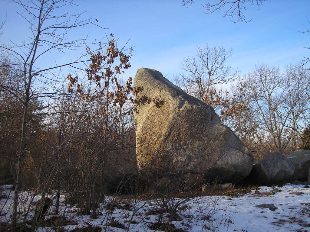
Whales Jaw (N1)
When Whales Jaw was first discovered hundreds of years ago, the rock was split in two, resembling the open jaws of a whale. In 1989, someone lit a fire under it, causing the “jaw” to crack and collapse. Like New Hampshire’s Old Man of the Mountain, which fell in 2003, the illusion is gone. Still, it is a powerful spot and worth the visit.
The photo below shows one of the more famous iconic views in Dogtown from the early 20th century.

(Image courtesy Sandy Bay Historical Society)
Wharf Cellar (24)
Cellar 24 is several hundred yards south of Benjamin Allen’s cellar on Wharf Road. After marrying Allen’s daughter, Mary and Abraham Wharf may have lived temporarily at the Allen home (Cellar 39) or next door (Cellar 40), and then moved to Cellar 24. Abraham’s sister Sarah, who was Peter Lurvey’s wife, lived just north of here at Cellar 25. According to the Massachusetts Tax Valuation List of 1771, Wharf, like many others who lived in the Commons, was a sheep farmer. Sadly, Abraham Wharf committed suicide in 1814. His wife passed away two years later.
Winslow Cellar (13)
Typical of some of the older and better-built cellars in Dogtown, many of the foundation stones that make up this cellar are still intact. It is not clear who built the house. Anthony Day and his son John Day received land grants in 1688 and probably built the first houses on Dogtown Road shortly thereafter. Joseph Winslow, also known as Deacon Winslow, was executor of John Day’s estate when Day died in 1724. Winslow married Sarah Day, John Day’s daughter. He is listed by Batchelder as living in a house here in 1741. Babson states that a Hannah Stevens lived here as well. A Hannah Stevens, probably related to Joseph Stevens, who lived next door at (13), married Samuel Day, Sarah Day Winslow’s nephew, in 1814. According to Mann, Stevens’ farm had the most livestock of any farm in Dogtown at the time.
Bibliography
Along the Old Roads of Cape Ann, Cape Ann Scientific and Literary Society, 1923.
John J. Babson, History of the Town of Gloucester, Cape Ann, Proctor Bros., Gloucester, MA, 1860.
Roger W. Babson and Foster H. Saville, Cape Ann Tourist’s Guide, Sandy Bay Historical Society and Museum, Rockport, MA, 1936. (Includes a map.)
Roger W. Babson, Actions and Reactions: An Autobiography of Roger W. Babson, Harper and Brothers, New York, NY, 1950.
Francis Blessington, The Last Witch of Dogtown, The Curious Traveler Press, Gloucester, MA, 2001.
Robert Brown and Gregory Gibson, “Bibliography of Books About Cape Ann.”
Mark J. Carlotto, The Dogtown Guide, Lulu Press, 2007.
Mark J. Carlotto, The Island Woods, Create Space, 2012.
Mark Carlotto, The Cellars Speak, Kindle Direct Publishers, 2015.
Melvin T. Copeland and Elliot C. Rogers, The Saga of Cape Ann, Bond Wheelwright Company, Freeport, ME, 1960.
W. H. Dennen, The Rocks of Cape Ann, 4 Canterbury Lane, Rockport, MA, 01966.
Developing a Management Program for Dogtown – A Report to the Mayor by the Dogtown Steering Committee, August, 1985.
Anita Diamant, The Last Days of Dogtown, Scribner, New York, 2005.
Thomas Dresser, Dogtown: A Village Lost in Time, Thorn Books, Franconia, NH, 1995.
Elyssa East, Dogtown – Death and Enchantment in a New England Ghost Town, Free Press, New York, 2009.
Richard B. Fisher, “The Dogtown Bull Fight”, February 12 1955. Sawyer Free Library Vertical File: Dogtown.
Mary E. Gage, The Stones of Dogtown and Beyond, Powwow River Books, Amesbury, MA, 2012.
Joseph E. Garland, The Gloucester Guide, The History Press, Charleston, SC, 2004.
Gloucester, Massachusetts, Names and Property of Early Settlers 1642-1714/15, Archives Committee, City of Gloucester, MA.
Christine Leigh Heyrman, Commerce and Culture: The Maritime Communities of Colonial Massachusetts 1690-1750, W.W. Norton & Company, New York, NY, 1984.
Percy MacKaye, Dogtown Common, https://play.google.com
Charles E. Mann, In the Heart of Cape Ann or the Story of Dogtown, Proctor Brothers, Gloucester, MA, 1896.
Helen Naismith, Walking Cape Ann with Ted Tarr, Ten Pound Island Books, Gloucester MA, 1994.
Charles Olson, The Maximus Poems, University of California Press, 1985.
Eleanor Pope, The Wilds of Cape Ann, Resources for Cape Ann (a project of the Massachusetts Audubon Society) and Essex County Ecology Center, Nimrod Press, Boston, 1981.
Hiram Rich, “Morgan Stanwood,” The Atlantic Monthly, June 1874, pp. 712-713.
Nathaniel Southgate Shaler, “Geology Of Cape Ann, Massachusetts – U. S. Geological Survey, 9th Annual Report,” http://hdl.handle.net/2027/nnc1.cu61321893
Irving Sucholeiki, A Return to Dogtown: A Look at the Artifacts Left Behind by Some of Cape Ann’s Early Settlers, Chisholm and Hunt Printers, Inc. Gloucester, MA, 1992.
Vital Records of Gloucester Massachusetts to the end of the Year 1849 (3 Volumes: Births, Marriages, and Deaths), The Topsfield Historical Society, Topsfield, MA, 1917.

Leave a comment